About The Netherlands
Locations of The Netherlands -- Where is Netherlands?
Netherlands (MEDC Country)The Netherlands, also known as Hollands, locates in Western Europe. The country borders the North sea along its western coast and in between Belgium (south) and German (East to North). Unlike it’s neighboring countries, Netherlands are known for having a low lying and flat gradient land area and is very prone to flooding. The Netherlands is deemed as a MEDC country (More economically developed country) which contains both coastal and polder land (when an immense amount of soil is poured into the sea to form a piece of land) alongside with several small hills. Due to its low lying land, many wind mills were built in Netherlands to pump water outside of the area, which causes a tremendous amount of canals in the country. By having an immense amount of canals could be both beneficial and disadvantageous to the country due to its geographical properties (low-lying and flat gradient land), as it increases the duration of flooding whilst lengthening the time for the country to flood during heavy rains.
Regardless, the Netherlands contains a main river system which is considered as the “Rhine Meuse Schooled delta”, which is combined by three main rivers -- the Rhine, Meuse, and Scheldt rivers, which flows through both the Europe mainland and the Netherlands. In this section, we provide a case study of 1993 flood in the Netherlands which had caused grave impacts to the country afterwards. Based on that, we will explore in details about the causes of the flood and negative and positive impacts towards the development of country in different aspects. News Broadcast on the concerns of Holland flooding |
The Rhine RiverThe Meuse RiverThe Scheldt River |
Floods in the Netherlands (1953)In this section, we provide a brief case study of one of Netherlands most devastating and representative floods in 1953 and several brief impacts it has made to the country.
1993 Netherlands flood: In early 1953, one of the most devastating floods occurred in Netherlands. Tremendously heavy rain poured in colossal parts of the Meuse and Rhine river, heavy enough that destroyed their river banks which leads to severe flooding in several countries including the Netherlands, France, Luxembourg, Belgium and Germany. The Rhine river enters the Netherlands from Germany on January 31st, indications recorded that the water level in land area is 13.48% higher than sea level. This caused 4 fatalities in Netherlands due to the severe impacts caused by this natural disaster alongside with 250,000 people evacuated from their home. Numerous cities were submerged under water for a duration of 3 days during January and February. This flood had significantly affected the country’s economic development as it damaged most of the country’s land and properties. 1993 Netherlands flood was chosen because firstly, its the most prominent flood that Netherlands had ever experienced, and it is one of the most devastating and representative floods in the Netherlands. Moreover, we will discuss and explain the natural and human causes of the flood alongside with the negative and positive impacts to the country's development in several aspects. |
Short Documentary on Netherlands flood in 1953 |
The Netherlands Natural Causes
Geographical LocationFirstly, Netherlands geographic position is located in the edge of Great European Plain, which is one of the four topographical units in Europe. Like Bangladesh, Netherlands is a low lying country. Only 50% of the country’s land area is one meter above sea level whilst 20% of it’s land area are located below sea level. As mentioned previously, a country having their land close to sea level will increase the risk of flooding due to land’s altitude which lacks the ability to prevent water from entering the land whereas countries with higher lying land (more above sea level) are capable to restrict water from entering land much easier than low lying countries.
Moreover, since the country locates at the edge of the Great European Plain and occupies some of land, this causes the country to contain a rather flat gradient (similar to Bangladesh). The reason why Netherlands are very prone to flooding, is because most of the land area is reclaimed by the sea whereas only 300 feet of the country’s land is over sea level. 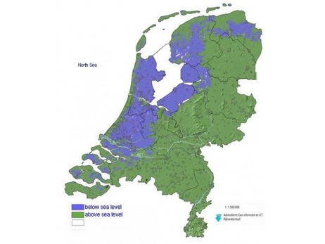
Varied Temperature ChangeIndications had shown that an average rainfall in Netherlands has caused the temperature to rise in an average of 1.5˚C, where by most part the temperature usually varies from 23˚ to 26˚C. Nonetheless, in 1953 Netherlands flood, the temperature tremendously rise from 24˚C to 28˚C. The increase of temperature change and the melting of snow in the Alps during the rainfall causes an escalated and intensified water supply. Resulting an earlier melting of snow in Alps due to the varied temperature change in rainfalls, which the Alps recorded a significant higher rate of melting in snow during Spring time. (Gallagher, 2008) The Rhine river increases extra water as the melted snow in Alps acts as the source of the river, which leads to overall increase of discharge and duration of flooding due to the excessive amount of sudden input emerged into the drainage basin.
|
Drainage Basin of the River Rhine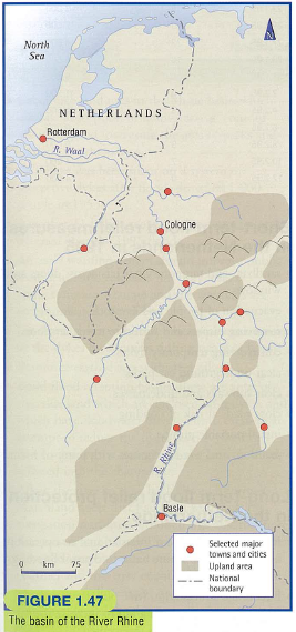
Heavy Rainfall
In Europe, heavy precipitation and continuous rainfalls lasted for months. As the heavy precipitation continues soil saturation were created which causes the ground to become impermeable. The lack of natural resources such as trees restricts the interception of rain which is use to decrease the rate of process, this is because the excessive rain water was not capable to infiltrate through the ground, hence restricts the process of groundwater flow and through flow. Thus causing a flood in River Rhine as the only way through process of surface run off on the ground was overflowing.

|
The Netherlands Human Causes
DeforestationDeforestation is one of the most prominent causes of floods in Netherlands. It is the process of cutting down trees to increase the available land for other usages and purposes. Deforestation occurs in a lot of countries across the world, one being in the Alps. A tremendous loss of trees and shrubbery will occur in the area caused by an immense scale of deforestation. Additionally, after the process of deforestation lands are now purposed for arable lands (lands that are suitable for growing crops) whilst it was originally purposed for pastoral reasons.
Consequently, this causes the removal of numerous plantations including meadows and hedgerows, hence reduces the capacity for evapotranspiration and interception. The main reason is because the roots in soils lessens which causes the process for water to infiltrate through the ground much easier. Thus, surface runoff will decrease hence the speed of the flood water flow through downstream will length, causes a reduction of lag time. As the percentage of rain entering the river increases, the flooding risk will also increase hence the channel capacity will decrease because of excessive amount of sediment transferred into the river channel. 
Developments of Urbanization and Shipping
Urbanization is another human causes to flooding in Netherlands in marshes and floodplains. Before urbanization occurred, marshes and flood plains are purposed to absorb excessive water in the river. Regardless, the development of urbanization, the purpose and ability of marshes and floodplains to take away excessive water was lost because the land area was cemented on agriculture such as roads and buildings. Due to this cemented land after urbanization, the impermeable ground surface restricts the water from infiltrating into the ground, hence decreases the lag time and leads to overland flow. Furthermore, the development of agriculture causes the loss of riverside marsh and flood plain, hence loses the ability to hold back floodwater.
Comparison of the Rhine River before and after Urbanization  (curved floodplains): Before being straightened for urbanizduring 1000-1200
(Straight floodplains): After being straightened for urbanization in 1995 Additionally, due to the fact that Rhine River acts as a prominent shipping highway mainly for shipping and trading, the river meanders was straightened to increase the pace and velocity and shortened the amount of distance. The journey distance originally of 1320 km from main source to the sea are now decreased by 50km. Initially, the curved meander requires to slow down the pace of the river flow so it could change directions, but after this development in the Rhine River was established, the water flow are capable to travel downstream much faster than it original ability/pace. Consequently, the increase in water traveling velocity could significantly affect the lag time and discharge, hence increases the risk of flooding in Netherlands. Positive and Negative Impacts of floodingNegative Impact (Economic)After the 1953 flood happened in Netherlands, severe impacts are made towards the country’s development economically as an immense amount of money was sent that was purposed to aid the victims affected by the flood alongside with other additional flood protection developments afterwards, which the Netherlands government decided to use 1 billion pounds towards flood protection developments after the 1953 flood. Other loss and aspects economically to the country’s development including repairing and rebuilding infrastructures destroyed and damaged by the flood, which also costs millions of pounds as a result. Moreover, the flood had destroyed 15500 km2 in total of farmlands, which affects the development and productions of agriculture and crops. Consequently, due to the severe impacts of the floods, the country’s transportation of goods were significantly reduced hence the country’s exportation was deeply impacted after the flood. (Short Term)
Negative Impact (Environment)After the 1953 flood, some areas were contaminated with toxic muds. Due to the overflowing of flood water, clean water supplies were also contaminated as a result. Moreover, due to the overflow, farmlands get submerged and saturated with water hence some lands will be impotent to produce crops and food in the following weeks or months hence difficulty in collecting food for citizens in Netherlands. (Short Term)
|
Global WarmingGlobal warming is one of the most concerned topics/issue in this era. Indications had shown that over the past century, the average temperature in South Europe had increased by 1˚C. Therefore as the temperature risen over time, the pace of melting of snow will increase in a faster pace, which also causes a 40% increase in winter precipitation. By increasing the pace of melting snow will lead to increase of immense surface run off and highly saturated soil that causes flooding to occur in Netherlands.
Building Hydro Electric power stations
Most parts in the upper part of the Rhine River had been altered due to the constructions of 10 Hydro Electric power station, which has also increases the risk of flooding in Netherlands. Since 1950’s, the upper part of the Rhine River alongside with the French and German border had been changed due to constructions of hydro electric power stations, which includes the process of creating new river that mirrors the old Rhine rive and the alterations of these hydro electric power stations can aid to build a deeper and faster Rhine River. Due to these constructions and alterations, the river water had increased the pace of flow and velocity, therefore once again, decreases the lag time hence increasing the risk of flooding.

Safety measures establishments in Netherlands
In Netherlands, establishments of safety measures and precautions including embankments were purposed towards the restriction of flooding towards upstream of Rhine River. Nonetheless, safety measures establishments including higher embankments installments enables floodwater direct towards downstream instead of upstream, which increases the pace as a result. As the water flows along a direction, the velocity increases at the direction/path the water travels which consequently affects the lag time and discharge of the flood.
Positive Impact (Political and Social)When looking at a social perspective, the impacts of the flood had caused a total of 4 fatalities and 250,000 citizens were made to evacuate from their homes. Mental stress were caused to a lot of victims that were affected by this flood as it destroyed and damaged a tremendous amount of housing, food and other basic necessities. Nonetheless, this flood had significantly raised awareness to neighboring countries such as Dutch and German towards prevention of flood. They have eventually created a flood preventative measures and other safety precautions establishments/developments including early warning systems which was purposed to improve public response to flooding within their countries. (Long Term)
Positive Impact (Environment)On the other hand, despite the negative impacts that had caused within the country, there are still various positive environmental impacts after the flood towards the country. This is because as downstream floodplains had been flooded, hence the water have to deposit a large amount of slit. This is a benefit towards Netherlands local environment because slit is a granular material and contains many nutrients and vitamins which is appropriate and suitable for farming lands and needs to increase the growing of crops with richer nutrients. (Short Term)
|
